GPS Devices and Apps
Handheld GPS devices, Mapping Software, GPX and KML, PC Software and GPS Trivia

A GPS device with an OS map - and a little marker on the screen saying "you are exactly here" - is brilliant. It makes life so easy - you will never get lost again.
However, paper maps are not dead yet. Here's why.
1) Electronic OS Maps are very expensive
There are many websites, this one for example, with free online OS mapping. However, to go walking, you will need a mobile device (satnav, pad, smart phone, Iphone, etc.) with an app to store the maps as mobile signal coverage in the countryside is very poor.
While dedicated walkers' satnavs are expensive, you may already have a smartphone, and the apps are quite cheap. The problem for both is that electronic OS maps are an additional cost - an they are expensive, very expensive.
The 1:50K (Landranger) scale maps are not too bad - £125 or so for the whole of the UK, but the excellent for walkers 1:25K OS Explorer series are much more expensive - £100 to £150 per county - that's much more than the paper maps.
And there's another twist, the electronic maps are not 'open'. Buy the electronic OS maps for one app (or satnav device), and they will not work in another, so you are stuck with that 'app'/device - or you will have to re-purchase the same very expensive maps all over again.
2) Handheld GPS Devices aren't perfect yet - Dedicated Satnavs vs Smartphones/Pads
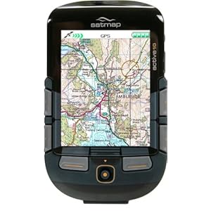
A dedicated GPS device, like the Satmap Active 10, is amazing and brilliant. Rugged, waterproof, OK screen size. The only drawback is its cost - its an expensive piece of kit - about £350 with 1:50K scale maps of the entire country. And, once you've purchased it, due to the expense, you're locked in. You can only use its maps on the Satmap device, and you can only buy maps for it from Satmap.
Memory-map and Garmin also have handheld GPS devices, but they are definately not recommended.
The other option is an app for your existing Smartphone (Android/Iphone) or Pad. The good bit is that there is competion for apps and the pads have larger screens. The problem is battery life. With the GPS enabled, you will only get a few hours battery life - nowhere near enough for a days walk. The design of the dedicated GPS devices have this in mind, they switch the screen off after a few secs, and don't update the GPS position so frequently. If you're walking, updating once every 10 secs is plenty.
There are several companies with smartphone apps, e.g. the OS and Anquet. Memorymap does as well, but it has poor reviews. Whichever one you choose, once you purchase maps for it, you're locked in.
OS Maps for you PC
PC Software
Anquet and Memorymap both have PC applications - but they are hard to recommend when so many websites now have free OS mapping. They are much easier to use than websites, with more features like 3D effects, but both much more expensive as you have to buy the maps. The only reason for using them would be to then load the maps onto your mobile smartphone or pad, or if you do a lot of route planning.
OS Map Websites
The OS have a slightly clunky but free website called Get-a-map. You can plan routes, and print out the latest 1:25K scale mapping from it. There are many others that have similar functionality.
GPS Trivia
Einstein and Relativity
As an aside, GPS is actually one of the few applied uses for relativity. The maths for working out the GPS location uses relativity as we are down a gravity well from the satellites, and time moves a little bit differently for them
Ronald Regan
After the 1983 shooting down of a Korean airliner which has wandered into Soviet airspace, Ronald Regan announced that GPS would be made freely available as a public good. Initially the signal was intentionally degraded to provide 100 metre accuracy, however, that was switched off in 2000, improving the accuracy to 20 metres for public use. Due to arms control restrictions, you may find you GPS device will not work above 18 kilometres (11 miles) altitude or faster than 515 metres per second (1,240 miles per hour) to prevent you using it as a component in a ballistic missile